Completion of Map Highlighting Areas Critical for Groundwater Recharge: Release of Water Environmental Map “Echigo Plain (Shinano River Basin)”
Summary of the AIST Press Release on April 12, 2024,
>>Japanese
The research team, including Isao Machida (Groundwater Research Group former Group Leader, currently Senior Planning Manager, Planning Headquarters, National Institute of Advanced Industrial Science and Technology (AIST)) and Reo Ikawa (Chief Senior Researcher) and Shinji Matsumoto (Researcher) of the Research Institute for Geo-Resources and Environment (AIST), collaborated with the Niigata Prefecture Geothermal Energy Utilization Study Group and Kowa Co., Ltd. to release a Water Environmental Map of “Echigo Plain (Shinano River Basin)”. Appropriate protection and use of groundwater require efforts from national and local governments, such as conducting groundwater monitors, survey and analysis and implementing restrictions on groundwater extraction (Basic Act on the Water Cycle, 2014). Taking such measures requires detailed groundwater surveys and efficient planning of such surveys necessitates a comprehensive understanding of the groundwater in the basin. The Water Environmental Map published in this study visualizes the entire hydrogeological picture in the Shinano River Basin, Echigo Plain, based on data obtained by compiling many fragmentary groundwater data and conducting field surveys using the latest methods. The map also visualizes recharge areas for groundwater resources mainly for snow-melting pipes (Figure. 1). Therefore, this map can be used for future groundwater management and urban development.
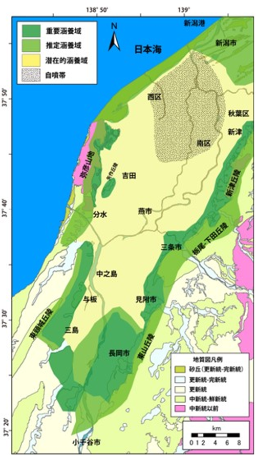
Fig. 1 Groundwater recharge areas for Echigo Plain. The recharge areas are classified into three zones: Critical recharge zone (green), Estimated recharge zone (light green) and Potential recharge zone (yellow).