Extraction of Areas at Risk of Slope Disasters Using Satellite Observations: Capturing Centimeter-Scale Signs of Landslides Using Microwave Satellite Image Analysis
Summary of the AIST Press Release on March 18, 2024,
>>Japanese
The research team consisting of Hiroki Mizuochi (Senior Research Scientist), Kazuhiro Miyazaki (Invited Researcher), Tomoya Abe (Senior Researcher), Daisaku Kawabata (Senior Researcher), Koki Iwao (Research Department Staff), Moe Matsuoka (Researcher), and Yoshinori Miyachi (Deputy Director) of the Research Institute of Geology and Geoinformation (National Institute of Advanced Industrial Science and Technology (AIST)), along with Hideo Hoshizumi (Technical Staff) of the Research Institute of Earthquake and Volcano Geology (AIST) conducted a microwave satellite image analysis in northern Kyushu to capture minute changes in slope topography over the past seven years and visualize areas at risk of slope disasters. The researchers also conducted an integrated analysis with geological and topographical information to reveal region-specific geological and topographical factors that contribute to higher risk. The researchers found that landslide risk was high on gentle slopes formed by past landslide deposits and around the border between sedimentary rocks and basalt, in addition to slopes facing northwest which coincide with the inclination direction of the geological structure. Conventional slope disaster risk assessment has been based mainly on topographical factors, but this research shows the importance of considering both geological and topographical factors. The highly detailed analysis was made possible by using time-series interferometric synthetic aperture radar (InSAR), a technique of interfering with microwave waveforms over multiple periods, which has seen widespread use in recent years. Time-series InSAR technique was used to analyze data from the Japanese Earth observation satellite Daichi-2 and capture centimeter-scale topographical changes with high spatial resolution (several meters). This information will contribute to national and local disaster prevention and mitigation plans.
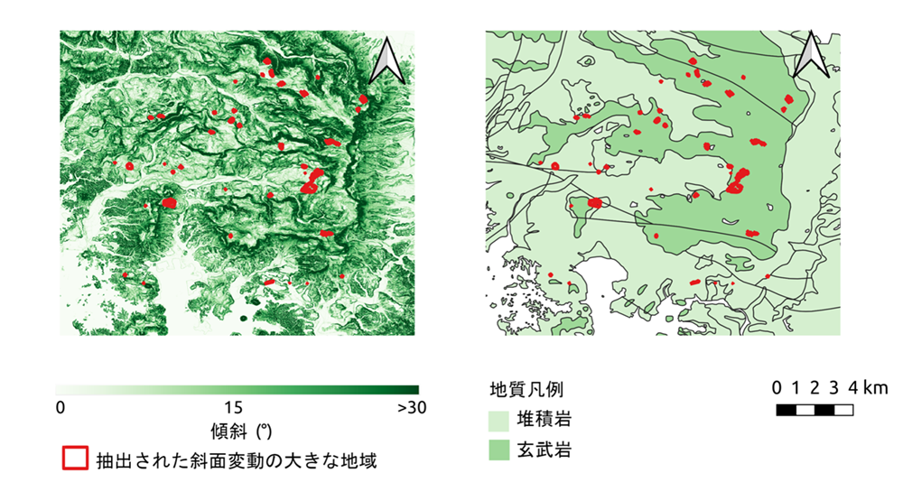
Fig. 1 Comparison relationship between (1) extracted large slope movement area (red) and slope (left figure) and (2) extracted large slope movement area (red) and geology (right figure). The large slope movement area distributes not only steep slope areas (dark green area in the left figure) but also gentle slope areas (pale green area in the left figure) which are mainly on the margin of the distribution area of basalt (dark green area in the right figure).
The slope map is based on DEM data from the Geospatial Information Authority of Japan. The geological map is based on the 1:200,000 Seamless Geological Map of Japan.