Revealing the Whole Picture of Hidden Massive Eruptions: Release of Detailed Distribution Map and Geological Information of Aso-3 Pyroclastic Flow
Summary of the AIST Press Release on March 18, 2024,
>>Japanese
The research team consisting of Nobuo Geshi (Caldera Volcano Research Group Leader), Shinji Takarada (Chief Senior Researcher) and Hideo Hoshizumi (Research Manager, at the time of research) of the Research Institute of Earthquake and Volcano Geology, National Institute of Advanced Industrial Science and Technology (AIST), and others have published a distribution map of the large-scale pyroclastic flow deposits from the Aso-3 eruption (Figure 1). This map can be downloaded from the AIST Geological Survey of Japan website (https://www.gsj.jp/Map/JP/lvi.html).
The study compiled the detailed distribution, thickness, and characteristics of the pyroclastic flow deposits into digital data, which were difficult to determine using conventional geological maps. Additionally, the distribution of volcanic ash that has accumulated over a wide area of the Japanese archipelago enabled the researchers to reveal the entire picture of the Aso-3 eruption—a massive eruption whose full extent was obscured due to being hidden by the Aso-4 pyroclastic flow deposits—and the extent of the impact of the Aso-3 eruption. The information on the occurrence history and impact of past massive eruptions is expected to be used in regional disaster prevention measures and land use plans.
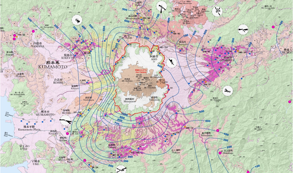
Fig. 1 Distribution Map of Aso-3 Ignimbrite (in the vicinity of Aso Caldera)