Visualization of “soft mud” beneath the Tama River Lowland
- Clarification of relationship between subsurface geology and past earthquake and subsidence disasters -
Summary of the AIST Press Release on April 27, 2022
>>Japanese
The Tama River Lowland, located on the west coast of Tokyo Bay, is a typical arcuate delta with an area of 160 km2. The lowland includes a large population and substantial property of the Tokyo Metropolis. During the 1923 Kanto Earthquake, a severe disaster struck this region, and since 1928, serious subsidence due to groundwater pumping has occurred in the area. These geological disasters can be understood by the existence of post-last glacial maximum (LGM) incised-valley fills (IVFs) consisting of unconsolidated soft sediments with high water contents. Clarification of the detailed distribution, physical properties, and development of the IVFs beneath the Tama River Lowland is crucial to mitigate future earthquake disasters and predict the intense subsidence presently occurring in large Asian cities located on riverine coastal lowlands.
In this study, we used data from 14 stratotype cores with 196 radiocarbon dates and 8700 borehole logs. These data comprise one of the densest datasets in the world for a single riverine coastal lowland. We also constructed a 50 m × 50 m × 1 m-grid voxel model from the borehole logs. The IVFs beneath the Tama River Lowland have a maximum thickness of 50 m, and they consist of transgressive sediments dated at 11‒8 ka and regressive sediments dated at < 8 ka. The bay mud, dated at < 10 ka, forms an enormous “soft mud,” with a spotty distribution beneath the Tama River Lowland. The distribution of the 1923 Kanto Earthquake disaster fits well with the thickness of IVFs. On the other hand, the distribution of the vertical displacement amount of the subsidence matches well with the thickness of the soft mud.
The Geological Survey of Japan, AIST published the geological information specific to the IVFs beneath the Tama River Lowland as the Atlas of the post-LGM incised-valley fills beneath the Tama River Lowland
(https://www.gsj.jp/researches/project/coastal-geology/miscellaneous-map/miscellaneous-map042.html). The atlas will additionally be published within a series to include other riverine coastal lowlands in Japan on which large cities are located.
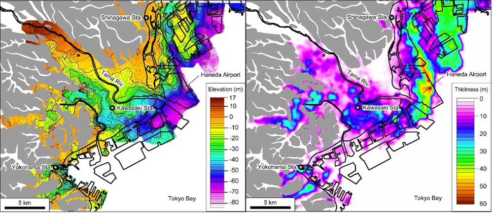
Fig. 1.Depth distribution of the LGM incised valleys (left panel) and
isopach map of the soft mud(right panel) beneath the Tama River Lowland. Pleistocene uplands are shown in gray.