Bulletin of the Geological Survey of Japan Top Page
Bulletin of the Geological Survey of Japan Vol.66 No.5/6 (2015)
Cover photograph | Table of Contents | Abstract
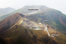
Cover photograph
A view of the northern side of Kuchinoerabu-jima and GPS observation stations.
Kuchinoerabujima is a volcanic island located 12 km west-northwest of Yakushima, Kagoshima Prefecture. Shindake crater is recent active center, which erupted on August 3, 2014 after a dormant period of 34 years. At this area, various phenomena have appeared after 1999, such as the increases of volcanic earthquake, ground deformation, magnetic anomaly, discharge rate of volcanic gas and so on. We have observed the ground deformation from 2004 by GPS networks including the location near the Shindake crater. Valuable data which suggest the preparation process of steam explosion were obtained from the observation.
(February 2010, Photograph by Nobuo Matsushima and Caption by Eiji Saito)
Table of Contents
All the pages PDF : 66_05_full.pdf [4.3MB]
| Title | Author | |
|---|---|---|
| Article | ||
| Ground deformation revealed by GPS observation for 10 years before the 2014 eruption in Kuchinoerabujima volcano |
Eiji Saito, Masato Iguchi and Nobuo Matsushima (p103-141)
|
66_05_01.pdf [3.1MB] |
| Long-term observation (2011 - 2014) of natural and artificial radionuclides transported with aerosols at the Geological Survey of Japan |
Yutaka Kanai (p143-157)
|
66_05_02.pdf [1MB] |
Abstract
Ground deformation revealed by GPS observation for 10 years before the 2014 eruption in Kuchinoerabujima volcano
Eiji Saito, Masato Iguchi and Nobuo Matsushima
Kuchinoerabujima is a volcanic island, which is located 40 km south of Kyushu, Japan. In recorded history, phreatic or magma-phreatic explosion occurred repeatedly with the dormant period of about 30 years. The recent eruption occurred on August 3, 2014 at the summit crater of Shindake, which is the youngest edifice of the volcano. Various phenomena, such as the increases of volcanic earthquake, ground deformation, magnetic anomaly and discharge rate of volcanic gas have occurred from 1999. These indicate the change of underground condition before the eruption. In order to evaluate the volcanic activity, we conducted continuous GPS observation from 2004 at two stations located at 230 m northwest (SDW) and 480 m south (FDK) of the summit crater of Shindake. The data sampled every 30 seconds are sent to our institute by telemetry system using mobile phone network. For the reference station of GSI (GEONET of Geospatial Information Authority of Japan) which is located at the northwestern foot of the volcano, stations SDW and FDK show the continuous trend of westward movement at the rate of 0.4 cm/ year. Intermittent events with sudden increase in the movement overlap these continuous deformations. We have observed the remarkable ground movements (2–4 cm in total) at 4 times; June in 2005, September in 2006, September in 2008 and October in 2010. These events lasted for more than a few months at respective events. They are characterized by the cumulative northwestward and upward movements of station SDW, and the slight southward movement of station FDK. The ground deformations at the summit area are explained by two sources; the intermittent ground deformation indicates the inflation of the source just under the summit crater of Shindake, and the continuous westward movement shows the deeper source which is located south-east of Shindake. The number of the volcanic earthquake increased at the same time of first and second events; however the increase of the seismic activity was sluggish at third and fourth events. The interval between the events had been prolonged gradually and another event of minute movements appeared on the continuous deformation after 2009. The movement due to the shallow source at the crater changed from dilatation to contraction, and another type of the deformations appear after 2013. These phenomena indicate the change of the deformation source condition just before the eruption.
Long-term observation (2011 - 2014) of natural and artificial radionuclides transported with aerosols at the Geological Survey of Japan
Yutaka Kanai
In order to obtain the geochemical knowledge of material cycle and to contribute the concern of inhabitant about safety after the accident of the Fukushima Dai-ichi Nuclear Power Plant (FDNPP), the aerosol observation at the GSJ was continued and the new data in 2014 as well as those from 2011 are reported in this paper. The Cs radioisotopes in aerosols in October 2011 decreased to 10-4 Bq/m3, one thousandth of those in April. In spring of each year, the concentration of Cs-137 decreased stepwise, to about 10-5 Bq/m3 in January 2015, probably owing to the change of climate conditions. Natural Pb-210 and Be-7 activities correlated each other and decreased in summer and winter. Traces of Ce-141, Ce-144 and Sb-125 were observed in some samples taken in 2011.
Geological Survey of Japan, AIST
- About GSJ
- Our Activities
- Purchase guide
-
Publications and Database
- information
- Bulletin of the Geological Survey of Japan
- bull2025(Vol.76)
- bull2024(Vol.75)
- bull2023(Vol.74)
- bull2022(Vol.73)
- bull2021(Vol.72)
- bull2020(Vol.71)
- bull2019(Vol.70)
- bull2018(Vol.69)
- bull2017(Vol.68)
- bull2016(Vol.67)
- bull2015(Vol.66)
- bull2014(Vol.65)
- bull2013(Vol.64)
- bull2012(Vol.63)
- bull2011(Vol.62)
- bull2010(Vol.61)
- bull2009(Vol.60)
- bull2008(Vol.59)
- bull2007(Vol.58)
- bull2006(Vol.57)
- bull2005(Vol.56)
- bull2004(Vol.55)
- bull2003(Vol.54)
- bull2002(Vol.53)
- bull2001(Vol.52)
- Bulletin of the Geological Survey of Japan(old)
- Annual Report on Active Fault and Paleoearthquake Researches
- Reports, Geological Survey of Japan
- CCOP-GSJ Groundwater Project Report
- CCOP Technical Bulletin
- Cruise Report
- Geological Hazards
- Learning and Education
- GSJ Database Collection
- Collection of links


