Cover and Back cover
Cover:
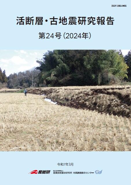
Surface deformation along the Wakayama River in Wakayama Town, Suzu City, Ishikawa Prefecture, appeared during the 2024 Noto Peninsula earthquake
The 2024 Noto Peninsula earthquake (Mj7.6) resulted in widespread uplift of the northern coast of the peninsula due to displacement along submarine active reverse faults off the peninsula. Moreover, onshore surface deformation has been reported at several sites on the peninsula. Among them, a narrow uplift zone accompanied by distinct scarps with heights on the order of meters appeared in an area where tectonically active structures were previously not recognized in Wakayama Town, Suzu City, as shown in the photograph. We report the results of field surveys and examination of the high-resolution topography to understand the details of the surface deformation that formed the uplift zone, and provide a preliminary discussion of the formation mechanism of the surface deformation. For details, see Maruyama et al. (1–23).
Back cover:
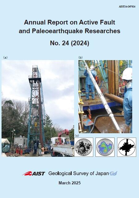
Geophysical logging of the borehole at the Ayagawa-Sembiki observation station in Ayagawa Town, Ayauta District, Kagawa Prefecture
(a) On-site drilling work at the Ayagawa-Sembiki observation station. A drilling rig, approximately 25 m high, was installed at the site to drill a borehole to a depth of 334 m. (b) A resistivity borehole wall imaging tool used for geophysical logging of the borehole. The tool's retractable pads (located about one-third from the lower end in the photo) contain button electrodes that are pressed against the borehole wall to measure the surface conductivity. The conductivity is converted into color variations to create an image of the borehole wall. Fracture analysis, as shown in the figure below, was conducted using the borehole images. (c) Distributions of the orientations for subsurface fractures intersecting the borehole. From the left, the figure shows the lower hemisphere equal-area projection of the poles to fracture planes, a contour plot of the distribution, and a rose diagram representing a histogram of the strike of the fractures after applying the dip angle correction. The two predominant orientations, ENE-WSW and NNE-SSE, roughly correspond to the characteristic strikes of the geological structures around the observation station. For details, see Kiguchi et al. (25–74).
Geological Survey of Japan, AIST
- About GSJ
- Our Activities
- Purchase guide
- Publications and Database
- Geological Hazards
- Learning and Education
- GSJ Database Collection
- Collection of links